We are proud that the Norwegian technical magazine “Teknisk Ukeblad” has written an interesting article about Kjeller Vindteknikk’s measurements in Sulafjorden. The full article may be read here (in Norwegian): https://www.tu.no/artikler/her-males-vinden-for-a-bygge-verdens-lengste-bruspenn/497917
For our non-Norwegian audience, we have an English summary below with the highlights.
Almost double size of the world’s largest bridge
The measurements from Kjeller Vindteknikk have been used to inform the design of a bridge crossing Sulaforden. The planned bridge will be almost double the size of the worlds’ largest bridge. The crossing of Sulafjorden is one of the three fjord crossings included in the project. The crossing is 3.8 km long and the fjord has a maximum depth of 500 m. As a comparison, Norway’s longest suspension bridge, “Hardangerbrua”, is 1380 m. The world’s longest span of a bridge is 1991 m, located in Akashai, Japan.
“The Sulafjord is open on both sides and not really a fjord. It enters sea with high waves and hard swells under water. Wind and currents come in from both sides. The water is surrounded by high mountains that results in complex wind gusts. Sulafjorden is the most extreme fjord I have worked with”, says Hasselø from The Norwegian Public Roads Administration (Statens Vegvesen) to Teknisk Ukeblad (TU).
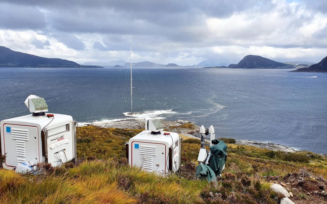
Lidar measurements
A buoy with a laser, located in the middle of the fjord, measures the wind at an altitude of 70 m. As there is an uncertainty in the accuracy of the bouy the additional measurements have been carried out . “In collaboration with Furgo and NTNU, we have developed a new lidar technology with vertical motion compensation. With new mathematic equations, we can calculate backwards to the results in a case when the laser is vertically fixed”, Hasselø says to TU.
Tested for validation
The last five years, lidar measurements have been performed from masts at strategic positions around the fjord. The gusts from the highest nearby mountains towards the fjord give cause to special conditions impossible to measure without the lidars. “The collaboration with Kjeller Vindteknikk in Lillestrøm has been important”, Hasselø says to TU.
Lofoten airport
The new technology developed for wind measurements in Sulafjorden has already been used in other areas.
“Without lidar measurements, the most suitable location of the new airport in Lofoten would still be undetermined”, Lars Tallhaug, Head of Department at Kjeller Vindteknikk, says to TU. “The aircraft approach in Lofoten includes high mountains. No one has managed to measure turbulence at high mountains in this way before. With the Lidar measurements we achieved actual measurements that are much better than the use of simulation models. The new technology makes it possible to measure the wind from very long distance and high in the air”, he continues.